|

- Home
- Trails
- Year of the Bridges
- SRT Sec 1 Bridges
Speed River Trail, Section 1 Bridges
By Liam Waterman, GHTC Volunteer
Section 1 of the Speed River Trail (SRT), which extends roughly from the Wastewater Treatment Plant at Wellington Road to Niska Road, is home to a large number of wooden footbridges. The trail itself is located on an outwash plain, a geographical area where silt, sand, gravel, and other fine debris have been deposited by the movement of glaciers.1 This porous mix of soil, which allows water to easily absorb into the ground, tends to prevent the formation of large tributaries or ravines. Instead, this section of the SRT contains a number of seasonal streams or wet spots that can become impassable depending on the water level of the river. The area has long been prone to flooding, and recent clearing on the land adjacent to this section has only increased the intake of water, making these bridges especially important to the trail’s accessibility.2 The existence of the majority of these bridges is owed to the work of Stan and Jana Stanek, who formerly served as joint trail captains of this section for the GHTC.
The Imperial Drain Bridge
The first bridge from the beginning of section 1 of the SRT crosses the Imperial Road drain, a storm water outlet that transfers water from the northwestern area of Guelph into the Speed River. The hilly, urbanized character of the catchment area prevents a large degree of water from being absorbed into the ground, leading to a relatively high volume flowing out through the drain instead. Although this channel can be easily hopped across during dry periods, the speed and height of the stream can increase dramatically during and after rainstorms, enough to make it difficult to wade across. The presence of a wooden bridge over the drain mitigates what would otherwise be a serious safety risk for trail users.

The bridge was initially installed in 2012, after almost four years of anticipation.3 Prior to 2007, the northmost part of section 1 of the SRT, on which the Imperial Road drain is located, diverged from the shore of the river to follow the side of Wellington Road. The trail was officially rerouted along its current path through City property after a series of talks in 2006 between SRT coordinator Bill Mungall and staff from the City of Guelph Parks department.4 Once this new route was put in place, it became clear to the GHTC that a structure was needed to span the Imperial Road drain, which was at the time traversable only by a series of stepping stones. However, the City informed the GHTC that they intended to connect this section to their Royal Recreation Trail (RRT), a project which would involve not only upgrading the section of trail between the drain and the beach volleyball courts at Silvercreek Park using stone dust, but also installing bridges over the two drains present on this section, the Imperial Road drain and the Northwest drain.5 Rather than building the bridge themselves, the GHTC decided to wait on progress from the city.
Unfortunately, the City’s construction plans were heavily delayed. In order to create their proposed connection, the City needed to negotiate for land usage with several private owners, including the Ontario Ministry of Transportation and the owners of the nearby quarry, River Valley Developments.6 Strained negotiations with River Valley Developments in particular halted all progress for several years, after which point the project continued to be postponed due to budget constraints. In 2010, the City informed the GHTC that stonedusting would be postponed until at least 2015.7 In 2011, Helen White, the Parks planner with the City, informed the GHTC that the City planned only to construct a bridge over the Northwest drain (which is further up on the trail) and not over the Imperial Road drain.8 The GHTC was thereby required to construct the Imperial Road Drain bridge themselves, after having waited for the City for almost three years.
Further complications from the City of Guelph continued to prevent the GHTC from bridging the Imperial Road drain for the rest of 2011. Stan and Jana Stanek had taken an interest in bridging the storm water channel during this period, and had presented drawings to the City for a proposed 3 foot high and 17-foot-long structure.9 The City rejected this plan, informing the GHTC that any structures located in the section of the trail on City property would need to be designed by a professional engineer and follow Ontario building codes.10 The proposed bridge would also require a permit from the GRCA. Bill Mungall unsuccessfully petitioned for the City and the GRCA to drop these requirements. Bill was later able to convince the City that a bridge following the standard design of the Bruce Trail Conservancy (BTC) would meet their requirements, and in 2012 came into contact with an engineer who designed the BTC’s bridges in its Trail Worker’s Guide.11 In the same year Bill began preparing an application to the GRCA for approval to construct abutments for this prospective bridge. Plans for the installation of a twenty foot bridge over the drain were set for 2013.12
In the meantime, Bill Mungall and a group of GHTC volunteers decided in 2012 to install a temporary solution to the bridge problem, a single sixteen foot long and ten inches wide plank which was laid over the crossing.13 This plank was tethered to each bank, and was propped up on cement blocks to keep it out of the current. In 2013 it was reinforced by Stan and Jana Stanek, who secured two 2 x 10 inch boards sideways across the existing plank. Bill recalls referring to this structure as a “plidge”, meaning something between a plank and a bridge. While the plans for the twenty-foot bridge never materialized, this plank continued to serve the GHTC for several years, until it was washed into the river during a period of strong weather in 2019. Peter Jaspers-Fayer, who had taken over as section leader from the Staneks, set out on his canoe in an attempt to locate the missing bridge, traveling as far as Cambridge before admitting that the bridge was lost. Bill Mungall believes that securing the bridge on both sides may have contributed to this outcome; while it was not regularly displaced in strong weather, the force of water directed at the tethers over time eventually led to both snapping at once, allowing the bridge to be completely dragged away.
Once this plank was lost, the GHTC decided to go ahead and install a simple wooden bridge over the crossing. This new bridge consisted of two sixteen-foot, 2 x 10-inch stringers, on which 2 x 6 decking boards were laid crosswise. Again, it was Bill Mungall, with a group of volunteers from the GHTC, who came out to complete this structure. This bridge, which still stands on the trail today, is significantly heavier than the past one, and has again been propped up on cinder blocks to keep it out of the path of the water. The bridge is also tethered only on one side, meaning that it can be washed onto the bank in the case of inclement weather without being broken away entirely. Despite technically never having given permission for this bridge to be constructed, the City has yet to raise any concerns about it.
Bill regularly comes to section 1 of the SRT to check on the bridge after periods of rainfall, walking in from the gates of a nearby snow dump and “pushing through the weeds” to access the bridge.14 Since the bridge continues to be washed away by the strength of water coming through the drain, these visits frequently require him to find it and lift it back onto its cement blocks. The frequent displacement of the bridge suggests that a more secure and elevated structure may be necessary for this crossing in the near future. The Imperial Road drain may be an ideal site for the GHTC to install a larger metal bridge, similar to the recent Gosling bridge or Crane Park Community bridge, both of which were purchased through community fundraising campaigns. Bill Mungall has considered perhaps looking to purchase such a bridge, or approaching the City about the project. “Something higher,” he says, would be beneficial for the trail.15 Perhaps there is still hope for a larger, engineered bridge over the Imperial Road drain.
Section 1 Bridges
There are six other wooden bridges located on section 1 of the SRT, all of which were built by Stan and Jana Stanek.16 When the retired couple took over the role of section leader from Steve Briant in 2002, they noticed that there were several uncovered shallow streams, or ditches, intersecting the southern half of their portion of the SRT. Many of these streams were dry for most of the year; however, when water levels were high, particularly during the spring, they became difficult to cross. Some of the streams required users to navigate across stepping stones, while others required users to either jump from bank to bank or wade through water. With the goal of making the trail more accessible all year round, and to avoid “getting their shoes wet” when they hiked the trail themselves, Stan and Jana decided to take it upon themselves to install a series of plank bridges.17
In 2004, the Staneks brought an estimated budget to the GHTC’s executives of $800 to purchase lumber for two proposed bridges.18 Their plans were approved, and in 2005 the Staneks began work. They ended up constructing five bridges over the course of the year, four of which were small wooden plank bridges, used to cross the small seasonal streams and wet spots present on the trail. These consisted of two 2 x 12-inch stringer boards, across which were laid a number of 2 x 6-inch planks for decking. At the bottom of either end of each bridge was another 2 x 12-inch plank serving as a sleeper. For the fifth bridge, the Staneks had to extend the design to a length of 42 feet, in order to cross a large storm water channel which intersects the trail at the location where currently the John Wood Side Trail rejoins the main line of the SRT. The Staneks received assistance in constructing this bridge from a large work party made up of other GHTC members, including Bill Mungall. The funding for these bridges, which were all completed within the year, came through a grant from the TD Friends of the Environment Foundation. This allowed the Staneks to purchase the lumber and nails necessary for their project.
In the years following installation the Staneks continued to work on these bridges. Despite being tethered, the bridges were frequently shifted out of place by flooding events experienced by the Speed River. This prompted the Staneks to reinforce the bridges in 2009, making them heavier, and therefore less likely to be picked up by water. The same year they also added some structural supports to the 42-foot bridge, which consisted of two metal poles secured on the bridge’s east side, one halfway across and one at the northern bank. At the locations of both of these metal poles the bridge was also propped up on cement blocks in order to keep it out of the range of high water levels. The Staneks added a sixth bridge the following year, of the same design as the others.
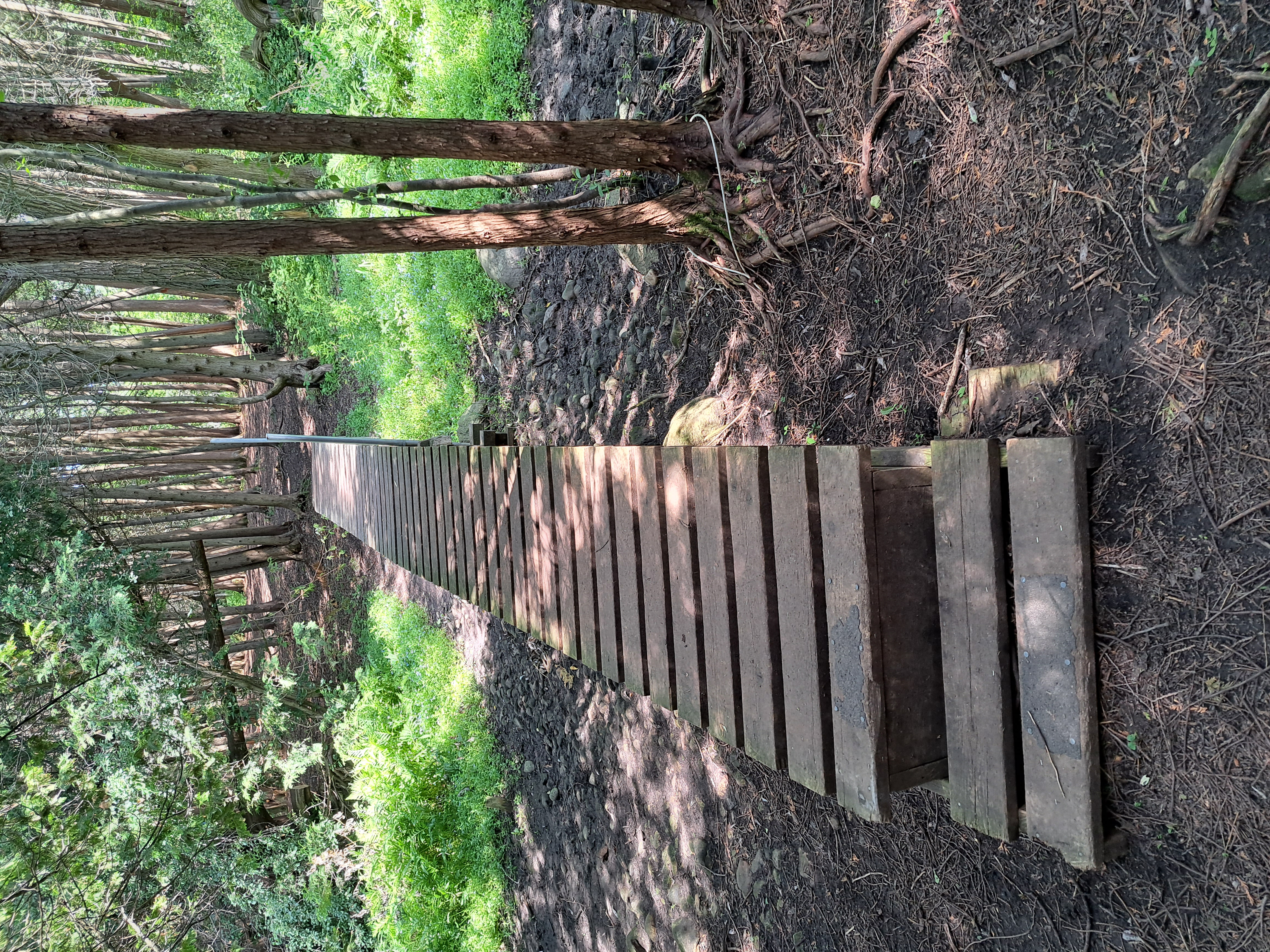
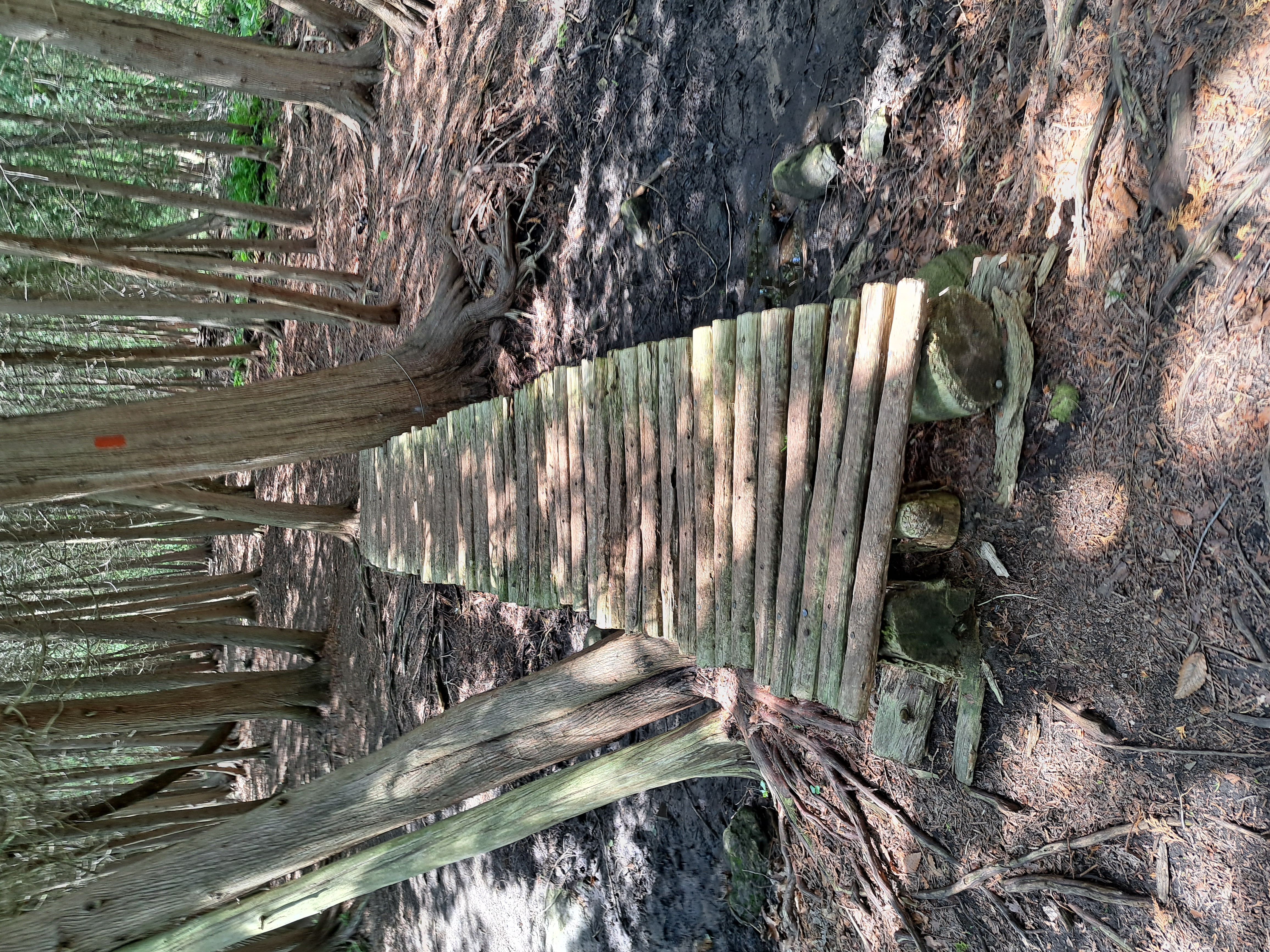
Since then, these bridges have survived with little need for maintenance. The only exception is one of the small footbridges, currently the third one from the beginning of the section at Niska Road, which began to break down in the following years due to rotting in the decking boards. Rather than being fixed by the Staneks, this bridge was at some point repaired by a passerby of unknown identity. Rather than replacing the decking boards with new planks, this unknown individual used a number of sapling trunks, which were stripped of their branches and cut to relatively even length. These saplings were nailed onto the original stringers, and the bridge was put back in place. This has given this bridge a relatively unique look among its fellows on section 1 of the SRT.
On the whole, these bridges remain a testament to the efforts of Stan and Jana Stanek in their role as section leaders. In 2012 the couple received a “Volunteers of the Year” award from Hike Ontario, recognizing their commitment and dedication to trail maintenance. Recently, a large section of land to the west of this section has been cleared, which has limited the absorption of ground water in that area. This has increased the ingress of water into section 1 of the SRT, making the bridges constructed by Stan and Jana even more important than they were when they were initially installed. Though they have now retired from their trail maintenance role, their work on section 1 of the SRT will certainly not be forgotten, and is no doubt appreciated by hikers every time they are able to cross the streams and keep their own shoes dry.
Notes
1. Theel, Markus, et. al. “Assessment of the Heterogeneity of Hydraulic Properties in Gravelly Outwash Plains: a Regionally Scaled Sedimentological Analysis in the Munich Gravel Plain, Germany”, Hydrogeology Journal 28, no. 8 (2020): 2658, https://doi.org/10.1007/s10040-020-02205-y.
2. Much of the information in this article, including that relating to the geography of this section of the Speed River Trail, was obtained through an in-person interview with SRT coordinator Bill Mungall, August 2023. Many thanks to him for his help in this project.
3. “Executive Meeting: Minutes of September 24, 2012”, Minutes, Newsletters, Handbooks, Posters, Scrapbooks, Correspondence and Other Items Relating to the Guelph Hiking Trail Club, 1970-, McLaughlin Library, University of Guelph.
4. “Executive Meeting: Minutes of March 23, 2006”, Minutes, Newsletters, Handbooks, Posters, Scrapbooks, Correspondence and Other Items Relating to the Guelph Hiking Trail Club, 1970-, McLaughlin Library, University of Guelph.
5. “Executive Meeting: Minutes of May 12, 2008”, Minutes, Newsletters, Handbooks, Posters, Scrapbooks, Correspondence and Other Items Relating to the Guelph Hiking Trail Club, 1970-, McLaughlin Library, University of Guelph.
6. Executive Meeting: Minutes of June 30, 2008”, Minutes, Newsletters, Handbooks, Posters, Scrapbooks, Correspondence and Other Items Relating to the Guelph Hiking Trail Club, 1970-, McLaughlin Library, University of Guelph.
7. “Minutes of the Annual General Meeting: November 18, 2010”, Minutes, Newsletters, Handbooks, Posters, Scrapbooks, Correspondence and Other Items Relating to the Guelph Hiking Trail Club, 1970-, McLaughlin Library, University of Guelph.
8. “Executive Meeting: Minutes of November 21, 2011”, Minutes, Newsletters, Handbooks, Posters, Scrapbooks, Correspondence and Other Items Relating to the Guelph Hiking Trail Club, 1970-, McLaughlin Library, University of Guelph.
9. “Executive Meeting: Minutes of January 17, 2011”, Minutes, Newsletters, Handbooks, Posters, Scrapbooks, Correspondence and Other Items Relating to the Guelph Hiking Trail Club, 1970-, McLaughlin Library, University of Guelph.
10. “Executive Meeting: Minutes of September 19, 2011”, Minutes, Newsletters, Handbooks, Posters, Scrapbooks, Correspondence and Other Items Relating to the Guelph Hiking Trail Club, 1970-, McLaughlin Library, University of Guelph.
11. “Executive Meeting: Minutes of March 26, 2012”, Minutes, Newsletters, Handbooks, Posters, Scrapbooks, Correspondence and Other Items Relating to the Guelph Hiking Trail Club, 1970-, McLaughlin Library, University of Guelph.
12. “Executive Meeting: Minutes of September 24, 2012”, Minutes, Newsletters, Handbooks, Posters, Scrapbooks, Correspondence and Other Items Relating to the Guelph Hiking Trail Club, 1970-, McLaughlin Library, University of Guelph.
13. Ibid.
14. In conversation with the author, August 2023.
15. Ibid.
16. In the process of researching this article, I had the privilege to conduct a phone interview with Stan Stanek, August 2023. Many thanks to him for his help in this project, and to both Stan and Jana for their work on section 1 of the Speed River Trail. I have been visiting this section since I was very young, and it has become a personal favorite of mine.
17. In conversation with the author, August 2023.
18. Executive Meeting: Minutes of November 18, 2004”, Minutes, Newsletters, Handbooks, Posters, Scrapbooks, Correspondence and Other Items Relating to the Guelph Hiking Trail Club, 1970-, McLaughlin Library, University of Guelph.
Guelph Hiking Trail Club is a charitable organization Registration#11894 9395 PO Box 1, Guelph, ON, N1H 6J6 |